GPSArtify
Europe

Strava art in Paris

These 4 Strava art routes were planned in Paris with our generator: an 11.3 km crescent moon, a flower centred on the 11th arrondissement, a four-leaf clover on both banks of the Seine and a 36.7 km dove.

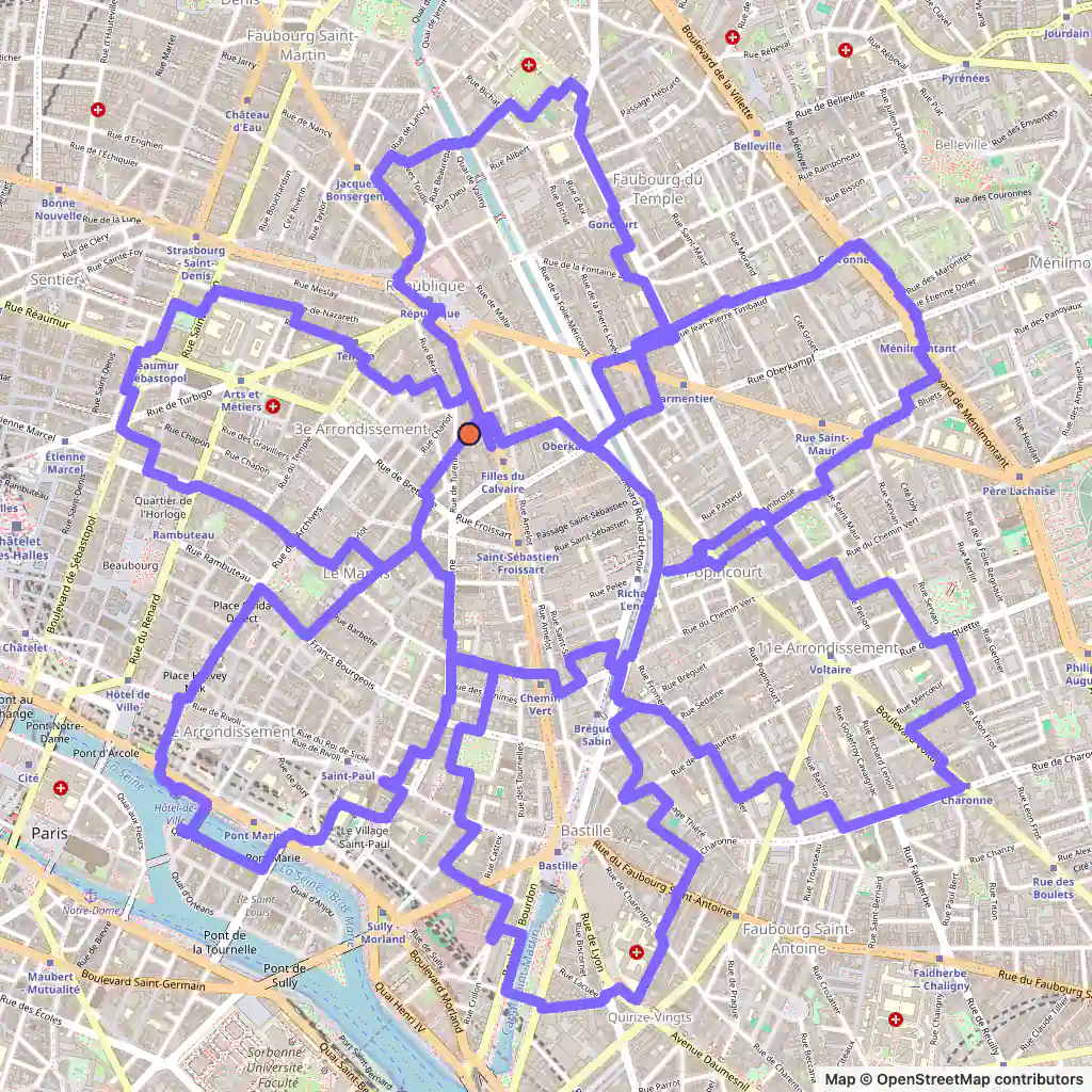
Strava art route: a flower drawn around the 11th arrondissement of Paris, starting near Place Olympe de Gouges
Flower, 22.4 km, Paris.

Strava art routes in Paris

  • Flower, 22.4 km, Paris. Its map is at the top of the page. Map © OpenStreetMap contributors

    Flower, 22.4 km

    Length
    22.4 km
    Mode
    Urban
    Starts near
    Place Olympe de Gouges
    Main streets
    Boulevard du Temple → Boulevard Voltaire → Boulevard Richard-Lenoir → Avenue Parmentier → Rue Vieille du Temple

    This flower starts near Place Olympe de Gouges and is centred on the 11th arrondissement, about 2.5 by 2.7 km.

    Boulevard Voltaire, Boulevard Richard-Lenoir and Avenue Parmentier are its longest streets, each about 700 m or more, and one petal reaches the Île Saint-Louis over Pont Marie and Pont Louis-Philippe.

    The flower's minimum in the generator is 20 km; fitted to these streets it grew to 22.4 km.
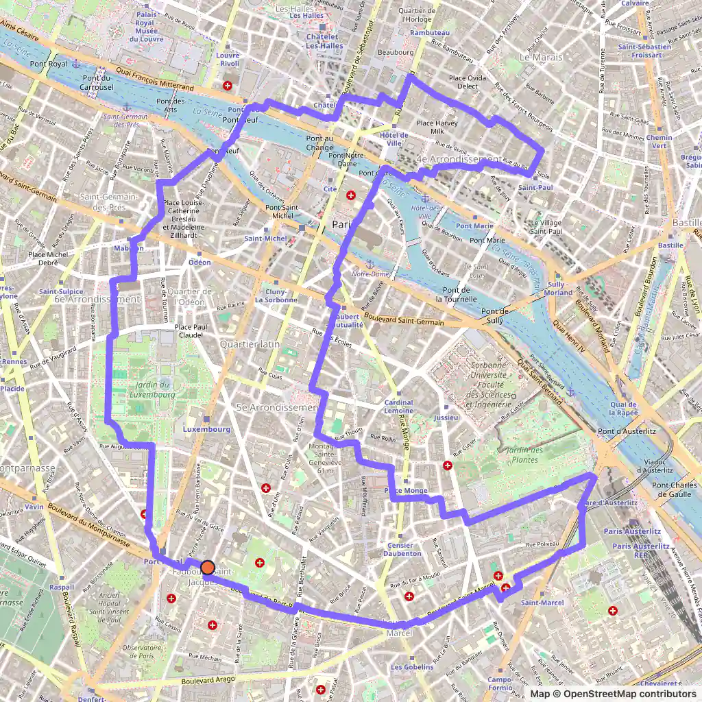
  • GPS art route: a crescent moon drawn across both banks of the Seine in Paris, starting near Cour Droussals in the 5th arrondissement
    Moon, 11.3 km, Paris. Map © OpenStreetMap contributors

    Moon, 11.3 km

    Length
    11.3 km
    Mode
    Urban
    Starts near
    Cour Droussals
    Main streets
    Boulevard de Port-Royal → Avenue de l'Observatoire → Rue Sainte-Croix de la Bretonnerie → Rue Buffon → Boulevard Saint-Marcel

    The shortest route here is an 11.3 km crescent that starts near Cour Droussals in the 5th arrondissement.

    It goes up Avenue de l'Observatoire, crosses to the Right Bank on Pont Neuf over the Île de la Cité and touches Rue Sainte-Croix de la Bretonnerie, then comes back over the island on Pont d'Arcole and Pont au Double and returns by Rue Buffon, Boulevard Saint-Marcel and Boulevard de Port-Royal.

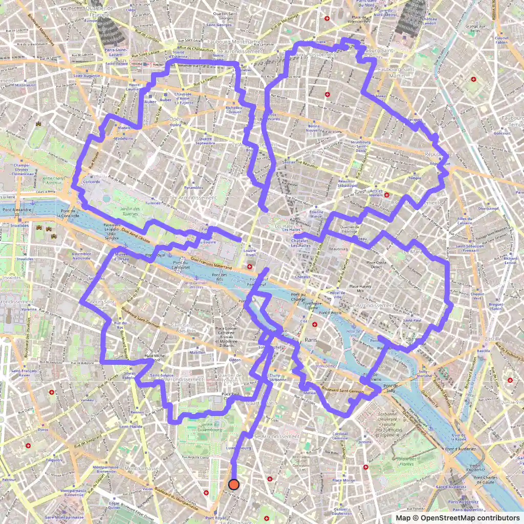
  • Strava art route: a four-leaf clover drawn across both banks of the Seine in Paris, starting near Place Ernest Denis
    Four-leaf clover, 28.3 km, Paris. Map © OpenStreetMap contributors

    Four-leaf clover, 28.3 km

    Length
    28.3 km
    Mode
    Urban
    Starts near
    Place Ernest Denis
    Main streets
    Boulevard Saint-Michel → Pont Neuf → Rue du Château d'Eau → Rue du Louvre → Rue de la Victoire

    The clover sets off near Place Ernest Denis and goes up Boulevard Saint-Michel to the river.

    It uses five bridges, Pont Saint-Michel, Pont Neuf, Pont Royal, Pont Marie and Pont de la Tournelle, and its leaves reach Rue du Château d'Eau, Place de la Madeleine and Place de la Concorde.

    In all it is 28.3 km over roughly 3.3 by 3.9 km.

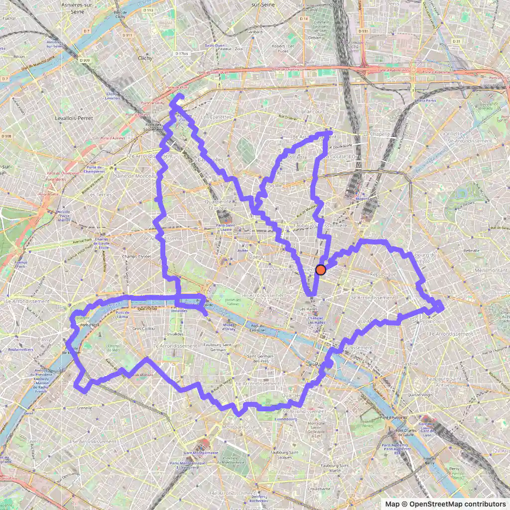
  • GPS art route: a dove drawn across Paris, from Pont de Bir Hakeim to the 18th and 11th arrondissements, starting at Place du Caire
    Dove, 36.7 km, Paris. Map © OpenStreetMap contributors

    Dove, 36.7 km

    Length
    36.7 km
    Mode
    Urban
    Starts near
    Place du Caire
    Main streets
    Rue Montmartre → Port de la Conférence → Avenue de New York → Avenue Duquesne → Avenue Parmentier

    The dove starts at Place du Caire and is the widest route here, about 6.7 km from west to east.

    Rue Montmartre is its longest street, about 800 m. In the west it runs beside the Seine on Port des Champs-Élysées, Port de la Conférence and Avenue de New York, and it crosses the Seine four times: on Pont de la Concorde, Pont Alexandre III, Pont de Bir Hakeim and, over the Île de la Cité, Pont au Double and Pont d'Arcole.

    At 36.7 km it is a ride; Avenue Parmentier, in the 11th arrondissement, comes near the end.

Generated with GPSArtify on 6 November 2026.

Paris as a Strava art canvas

Paris sits in a north-bending arc of the Seine, whose crest holds the city's two natural islands, the Île de la Cité and the Île Saint-Louis. The city spreads over both banks and is relatively flat; Montmartre, at 130 m, is its highest hill. The Boulevard Périphérique, a 35 km ring road, encloses an oval of about 87 km², divided into 20 arrondissements that spiral clockwise.

All four of our routes reach the islands or cross the river. The moon goes over the Île de la Cité on Pont au Double, Pont d'Arcole and Pont Neuf, and the flower touches the Île Saint-Louis on Pont Marie and Pont Louis-Philippe. The clover uses five bridges, among them Pont Royal, and the dove crosses four times, from Pont de Bir Hakeim in the west to Pont d'Arcole.

Drawn by the GPSArtify team in Paris

The GPSArtify team planned this Eiffel Tower across Paris; it is also on our Strava art ideas page.

  • Strava art example: the Eiffel Tower drawn across Paris
    Eiffel Tower, Paris

Strava art ideas by shape

Plan your Strava art in Paris

  1. Open our Strava art generator, the GPS art generator that planned this GPS art, and move the map to Paris.
  2. Pick a shape and a distance; the route is fitted to real streets.
  3. Export the GPX to Strava, Garmin, Wahoo or Komoot, then run or ride it.