GPSArtify
Europe

Strava art in London

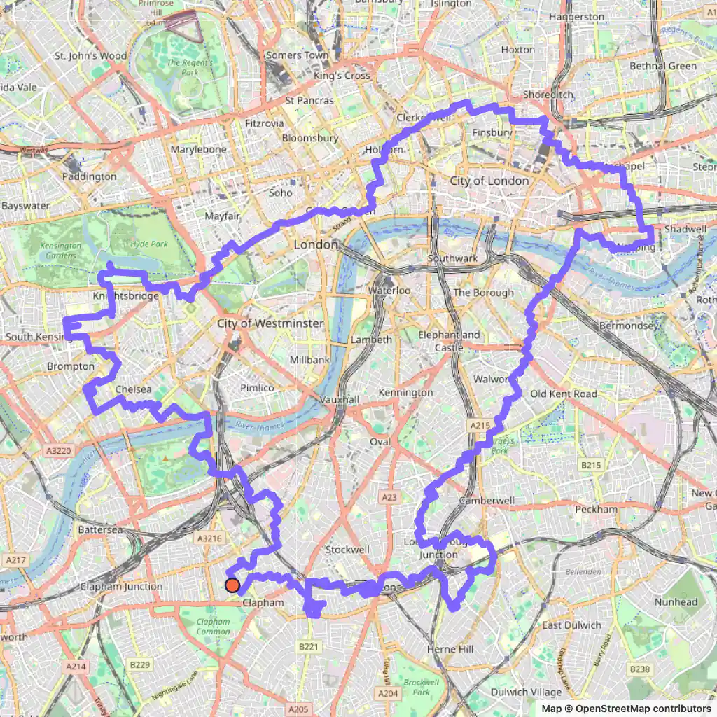
4 Strava art routes on London's streets, planned with our generator: an 11.3 km infinity sign and a pi that stay north of the river, and a butterfly and a bird that cross it.

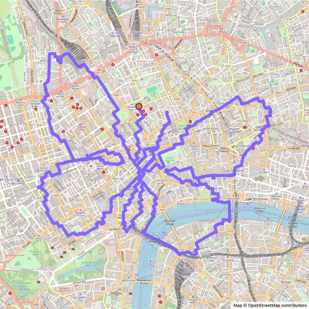
Strava art route: a butterfly drawn across central London, starting near Russell Square station
Butterfly, 27.2 km, London.

Strava art routes in London

  • Butterfly, 27.2 km, London. Its map is at the top of the page. Map © OpenStreetMap contributors

    Butterfly, 27.2 km

    Length
    27.2 km
    Mode
    Urban
    Starts near
    Russell Square
    Main streets
    High Holborn → Kingsway → Great Queen Street → Fleet Street → Oxford Street

    The butterfly sets off by Russell Square station and its four wings meet around High Holborn, Kingsway and Great Queen Street.

    One wing dips south of the Thames, where it takes Stamford Street; it crosses the river on Blackfriars Bridge and on the Golden Jubilee Bridge.

    Oxford Street is its longest street, about 800 m in all, and the whole figure fits in roughly 3.2 by 2.8 km.
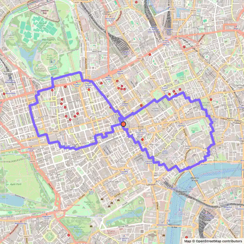
  • Strava art route: an infinity sign drawn north of the Thames in London, starting at Rathbone Square
    Infinity, 11.3 km, London. Map © OpenStreetMap contributors

    Infinity, 11.3 km

    Length
    11.3 km
    Mode
    Urban
    Starts near
    Rathbone Square
    Main streets
    Oxford Street → Cleveland Street → Marylebone Road → Outer Circle → Gloucester Place

    At 11.3 km this infinity sign is the shortest London route here, a distance to run, and it begins right at Rathbone Square.

    Its two loops span about 3.3 km from west to east but only 1.7 km from north to south. Its longest streets, Cleveland Street, Gloucester Place, Oxford Street, the Outer Circle and Marylebone Road, are all in the western loop; the eastern loop reaches down to the Strand.

    It never crosses the river.

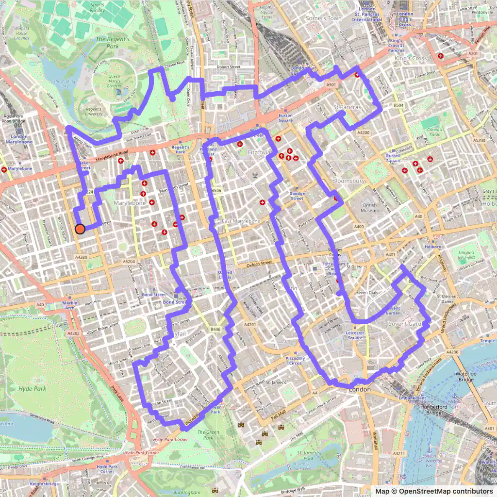
  • Strava art route: the pi symbol drawn north of the Thames in central London, starting near Paddington Street Gardens in Marylebone
    Pi, 19.5 km, London. Map © OpenStreetMap contributors

    Pi, 19.5 km

    Length
    19.5 km
    Mode
    Urban
    Starts near
    Paddington Street Gardens South
    Main streets
    Harley Street → Regent Street → Tottenham Court Road → Charing Cross Road → Outer Circle

    The pi begins near Paddington Street Gardens in Marylebone and fits in a square of roughly 2.6 km each way.

    Its five longest streets, each 450 m or more, are Harley Street, Regent Street, Tottenham Court Road, Charing Cross Road and the Outer Circle.

    We asked for 20 km, the shortest distance the generator offers for this shape, and it came back at 19.5 km.

  • Strava art route: a large bird drawn across both banks of the Thames in London, starting near Holy Trinity Churchyard in Clapham
    Bird, 44.2 km, London. Map © OpenStreetMap contributors

    Bird, 44.2 km

    Length
    44.2 km
    Mode
    Urban
    Starts near
    Holy Trinity Churchyard
    Main streets
    Stewarts Road → Rotten Row → Piccadilly → Ferndale Road → Bedford Road

    This 44.2 km bird, about 8.4 km wide, leaves from Holy Trinity Churchyard in Clapham; at this length it is a ride.

    It goes over the Thames on Chelsea Bridge, runs along Rotten Row and Piccadilly on the north side, and comes back across on Tower Bridge.

    On the way back south it follows Ferndale Road and Bedford Road.

Generated with GPSArtify on 6 November 2026.

London as a Strava art canvas

The Thames is London's main geographical feature. It crosses the city from the south-west to the east, and since the Victorian era it has run between embankments, with many of its London tributaries now underground.

For drawing, the river is the line every shape has to respect. Our butterfly crosses it on Blackfriars Bridge and the Golden Jubilee Bridge, the bird on Chelsea Bridge and Tower Bridge. The infinity sign and the pi stay north of it.

Distances stretch or shrink once a shape meets real streets. The bird grew the most: asked for 38.2 km, it came out at 44.2 km. The infinity went from 10.2 to 11.3 km and the butterfly shrank from 30 to 27.2 km.

Plan your Strava art in London

  1. Open our Strava art generator, the GPS art generator that planned this GPS art, and move the map to London.
  2. Pick a shape and a distance; the route is fitted to real streets.
  3. Export the GPX to Strava, Garmin, Wahoo or Komoot, then run or ride it.